

Merapi (peak height of 2968 m above sea level, as of 2006) is a volcano in the central part of Java Island and is one of the most active volcanoes in Indonesia. Slopes of the south side are in administration Sleman, Yogyakarta Special Region, and the rest are in the region of Central Java Province, which is on the west side of Magelang regency, Boyolali District on the north and east, and Klaten on the southeastern side. Forest area around the peak became Mount Merapi National Park area since 2004.
The mountain is very dangerous because, according to modern records have erupted (peak activity) every two to five years and is surrounded by very dense settlements. Since 1548, this mountain has erupted 68 times as much. [Citation needed] The city of Magelang and the city of Yogyakarta is the nearest large city, is under 30 miles from its peak. On the slopes there is still a settlement to a height of 1700 m and is just four kilometers from the summit. Because of this interest rate, Merapi became one of sixteen volcanoes of the world are included in Decade Volcano projects (Decade Volcanoes)
Geologi
Mount Merapi is the youngest mountain in the volcanic sequence that leads to the south of Mount Ungaran. The mountain is formed by the subduction zone of activity in the Indo-Australian Plate is moving under the Eurasian Plate to cause the appearance of volcanic activity along the central part of Java Island. The peak is now overgrown with vegetation is not because of high volcanic activity. This peak grows in the southwest side of the peak of Mount Batulawang older.
The process of formation of Mount Merapi has been studied and published since 1989 and onwards. Berthomier, a French scholar, divided into four stages of development Merapi first stage is the Pre-Merapi (up to 400,000 years ago), namely the Mountain Aunt parts can still be seen on the east side of the peak of Merapi. Stage occurs when the Old Merapi Merapi began to take shape but not conical (60000-8000 years ago). The remains of this phase is Turgo Hill and Hill Plawangan in the south, which is formed of basaltic lava. Next is the Middle Merapi (8000 - 2000 years ago), characterized by the formation of high peaks, like Mount Gajahmungkur and Batulawang, which is composed of andesite lava. During the formation process is characterized by lava flows, brecciation of lava and hot clouds. Activities are effusive eruptions of Merapi has (melt) and explosive. It is estimated that explosive eruptions also occurred with the collapse of material toward the west that left the horseshoe morphology with a length 7 km, a width of 1-2 km with a few hills on the western slope. Pasarbubar crater (or Pasarbubrah) predicted to form at this time. Merapi peak current, peak Anyar, just beginning to form around 2000 years ago. During its development, is known to occur several times an explosive eruption with VEI 4 based on observations tefra layer.
Characteristics of eruption since 1953 is the insistence of lava into the summit crater is accompanied by periodic lava dome collapse and pyroclastic formation (nuee ardente) which can slide on the slopes or vertically upward. The eruption of Merapi type is generally not a sound but the hiss of the explosion. Dome top which existed until 2010 was the result of ongoing process since the eruption of gas in 1969.
Geologists in 2006 detected a giant space beneath Merapi containing materials such as mud that is "significantly impede the vibration wave earthquake". Scientists estimate that the material is magma] pockets of magma is part of the formation formed by the Indo-Australian Plate menghunjamnya under the Eurasian Plate.Small eruptions occur every 2-3 years, and the larger about 10-15 years.
Merapi eruptions recorded a big impact in the year 1006 (allegations), 1786, 1822, 1872, and 1930. The eruption in the year 1006 makes the whole enveloped in the central part of Java Island ash, based on observations of volcanic ash deposits.
Dutch geologist van Bemmelen, theorizes that the eruption caused the center of the Kingdom of Medang (Mataram) should be moved to East Java. The eruption in 1872 is considered as the strongest eruption in modern geological record with VEI scale reaches 3 to 4. Recent eruption, in 2010, is expected also to have power close to or equal. The eruption of 1930, which destroyed thirteen villages and killed 1400 people, is the biggest victims of the eruption with a record until now.
November 1994 eruption caused the hot clouds glide down until reaching some villages and claimed 60 human lives.
July 19, 1998 eruption is quite large but pointing upwards so that no casualties. Note the last volcanic eruption was in 2001-2003 in the form of high activity are ongoing. In 2006 Mount Merapi high-return activities and had swallowed two lives Kaliadem volunteers in the region due to hit the brunt of the hot cloud.
The series of eruptions in October and November 2010 were evaluated as the largest since the eruption in 1872 and claimed the lives of 273 people (as of 17 November 2010),although it has imposed intensive observation and preparation for evacuation management.
The eruption of 2010 also observed as a deviation from the eruption "Merapi type" because it is accompanied by explosive sounds and thunderous explosions that sounded up to a distance of 20-30 km.
The volcano is monitored non-stop by the Center for Observation of Mount Merapi in Yogyakarta, assisted by various geophysical instruments telemetry around the mountaintop observation posts and a number of visual and seismic recorder in monitoring (Srumbung), Babadan, and Ground.
Eruption of 2006

In April and May 2006, began to appear signs that Merapi will erupt again, is characterized by earthquakes and deformation. The local government of Central Java and Yogyakarta have prepared evacuation efforts.Instructions also have been issued by both local governments so that residents living near Merapi immediately flee to places that have been provided.
June 1st, rain of volcanic ash from Mount Merapi, hot clouds glide dense, three days later this happened and in Magelang Magelang regency, Central Java. Muntilan about 14 kilometers from the summit of Merapi, most felt this ash. June 8, Mount Merapi erupted at 9:03 pm with a blast of hot clouds that made thousands of residents in the area of the slopes of Mount Merapi panicked and attempted to flee to safety. Today recorded two eruptions of Merapi, a second eruption occurred at around 09:40 pm. A burst of hot clouds as far as 5 km further leads to the upper Kali Gendol (southern slopes) and destroyed most forests in the north Kaliadem in Sleman region.
Eruption of 2010
Increasing the status of "normal active" to "alert" on September 20, 2010 recommended by the Center for Investigation and Technological Development Kegunungapian (BPPTK) Yogyakarta. After about a month, on October 21, status changed to "idle" since at 18:00 pm. At this level of displacement activities have to be prepared. Because of increasing activity,
indicated by a high frequency multiphase earthquakes and volcanic earthquakes, since 06.00 am October 25 BPPTK Yogyakarta tangggal recommends increasing the status of Mount Merapi to "alert" and all the inhabitants of the area within a radius of 10 km from the summit should be evacuated and evacuated to safe areas.
The first eruption occurred at around 17:02 pm on 26 October. Occur until at least three times the eruption. Volcanic eruptions eject material as high as approximately 1.5 miles and accompanied the release of heat clouds which swept Kaliadem, Kepuharjo Village, Cangkringan Subdistrict, Sleman.dan killed 43 people, plus a baby from Magelang who died because of respiratory disorders.
Since then regurgitated hot clouds started happening on an irregular basis. Starting October 28, Mount Merapi spewed lava that appeared almost simultaneously with the discharge of hot clouds at 19:54 pm. Next start hotspots observed silence at the top on November 1, marking a new phase that the magma has reached the pit crater.
However, different from the character of Merapi typically, rather than the formation of a new lava dome, which in fact happened was increased activity bursts of lava and hot clouds since November 3.
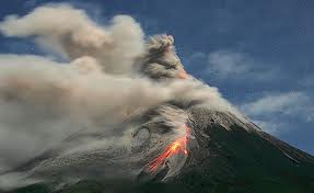
Explosive eruption of a major eruption began on the morning of Thursday, November 4, 2010, resulting in cloud fields as high as 4 km and bursts of hot clouds in different directions at the foot of Merapi. Furthermore, since about three o'clock in the afternoon eruption that will not cease until the evening and reached its peak in the early hours of Friday, November 5, 2010.
Toward midnight, the radius of danger to all the places enlarged to 20 km from the summit. This series of eruptions and rumbling sounds to the city of Yogyakarta (distance about 27 km from the summit), Magelang and Wonosobo district center (distance 50 km). The rain of gravel and sand reach the northern city of Yogyakarta, while the thick rain of volcanic ash up Navan and Cilacap struck. In the afternoon, volcanic ash is known to have reached Tasikmalaya, Bandung, and Bogor.
Secondary hazards of cold lava flow also threatens the region lower on 4 November after heavy rains occur around the peak of Merapi. On November 5 of the Code in the region of Yogyakarta declared status "alert"
Strong eruption 5 November followed by a high activity for about a week, before then there was a slight decrease in activity, but the security status remains "Caution". On 15 November 2010 to limit the danger radius of Magelang regency reduced to 15 km and for two other districts of Central Java to 10 km. Just for the District. Sleman that still remain in place 20 km radius of danger.
Vegetasi
Mount Merapi at the top is never overgrown vegetation due to high activity. Plant species at the top of the type typical alpina mountains of Java, such as Rhododendrons and edeweis java. There is a little down the mountain forests of bamboo and tropical plants.
The slopes of Merapi, particularly below 1,000 m, is the place of origin of two cultivars of national superior barked, barked that 'Pondoh' and 'Nglumut'.
Climbing routes
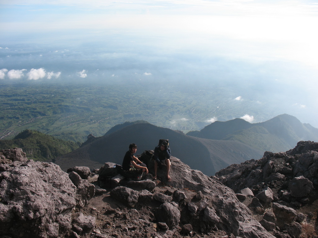
Mount Merapi is the object of a popular climb. because this mountain is a mountain that is very charming. The most common route is through the side and near north of Selo, Boyolali regency, Central Java, precisely in the Village Tlogolele. The village is located between Mount Merapi and Mount Merbabu. Climbing through Selo take about five hours to the summit.
Another popular path is through Kaliurang, District Pakem, Sleman, Yogyakarta on the southern side. This path is more steep and takes about 6-7 hours to the summit. Another alternative pathway is through the northwestern side, starting from Sawangan, Magelang regency, Central Java and through the southeast side, from the direction of Deles, District Kemalang, Klaten regency, Central Java.
Permalink : Mount Merapi INDONESIA
Sharing Caring :
0 comments:
Post a Comment